41 Unusual Maps Of The US You Probably Never Seen Before
People are sharing unique maps of the U.S. that reveal the often-overlooked side of the country.
Independently testedUnbiased Demilked scoreFree to implementTools included
Stretching out a whopping 3.8 million square miles (9.8 million km2), the United States is one of the biggest countries in the world. And with it having numerous cities, rivers, forests, and Waffle Houses, it can be quite difficult to fit all that information on a single map. That's why some people started creating unique maps of the U.S. that reveal the often-overlooked side of the country.
People are sharing rarely-seen maps of the United States and they might help you see the country from a different perspective. From maps showing the huge population differences in different counties to more abstract ones showing the eye colors of the governors of each state - check out the U.S. maps you probably never seen before in the gallery below!
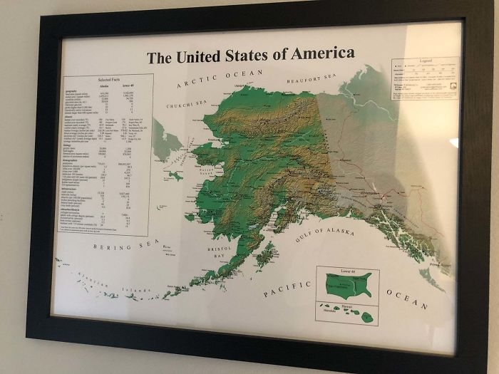 Image source: reddit.com
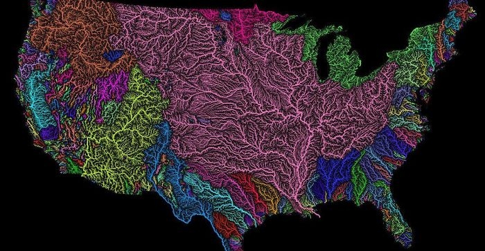 Image source: reddit.com
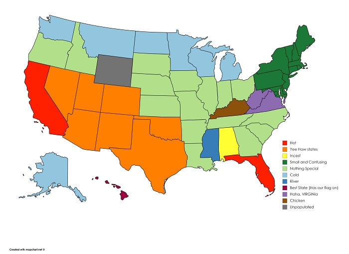 Image source: reddit.com
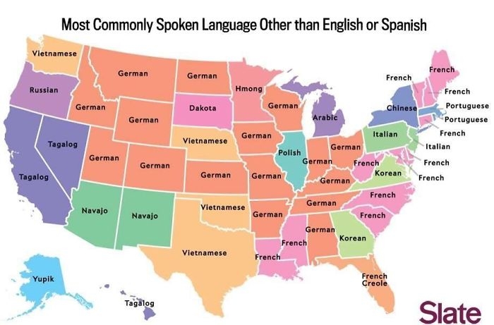 Image source: reddit.com
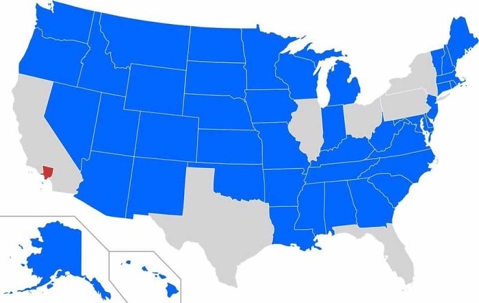 Image source: reddit.com
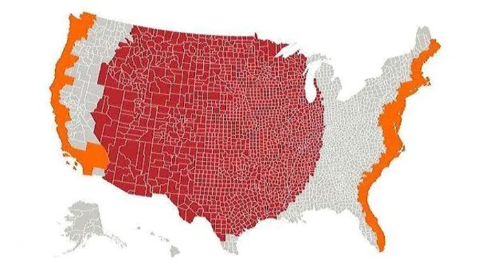 Image source: Cogo5646
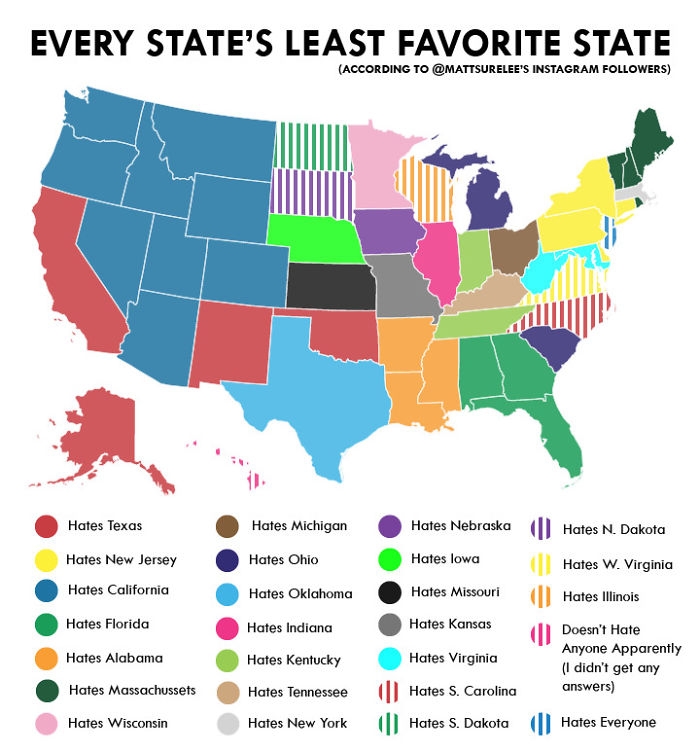 Image source: reddit.com
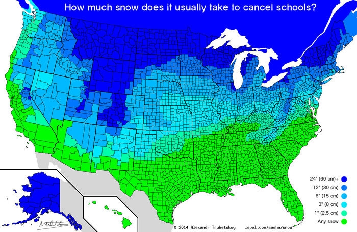 Image source: reddit.com
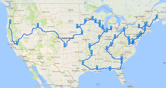 Image source: reddit.com
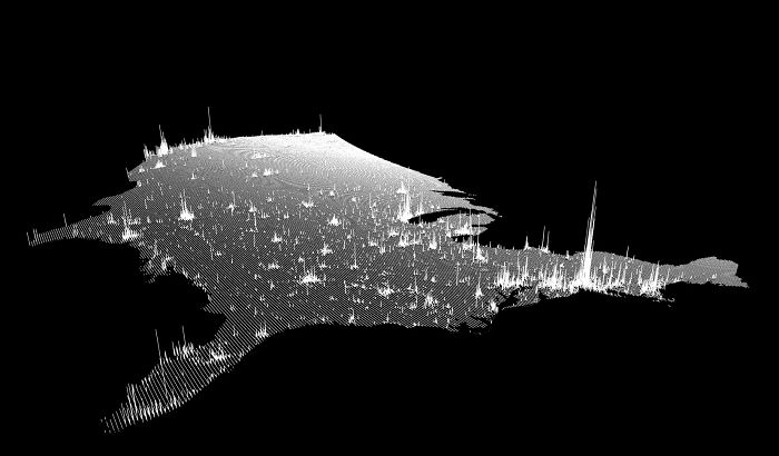 Image source: reddit.com
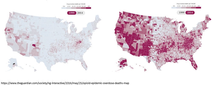 Image source: reddit.com
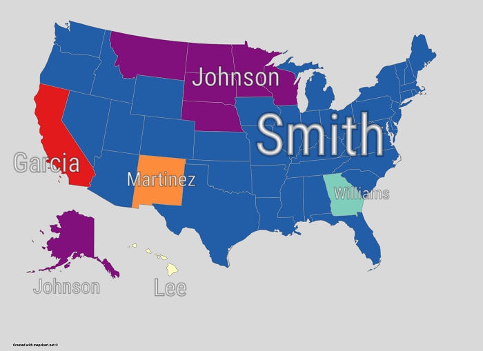 Image source: reddit.com
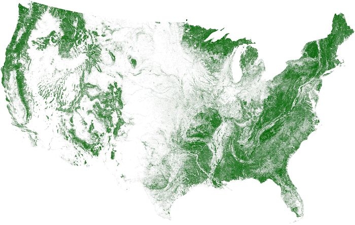 Image source: reddit.com
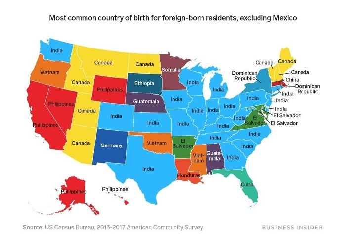 Image source: reddit.com
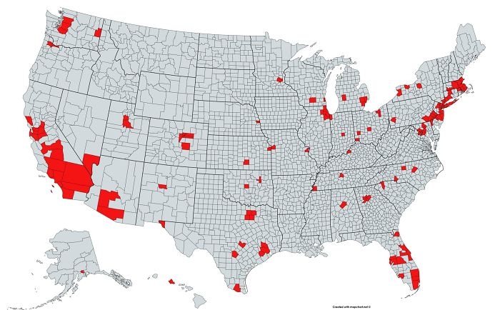 Image source: reddit.com
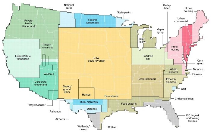 Image source: reddit.com
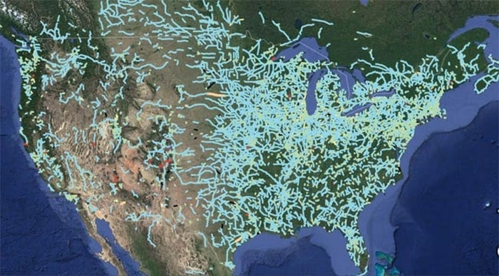 Image source: Andrew Grigg/
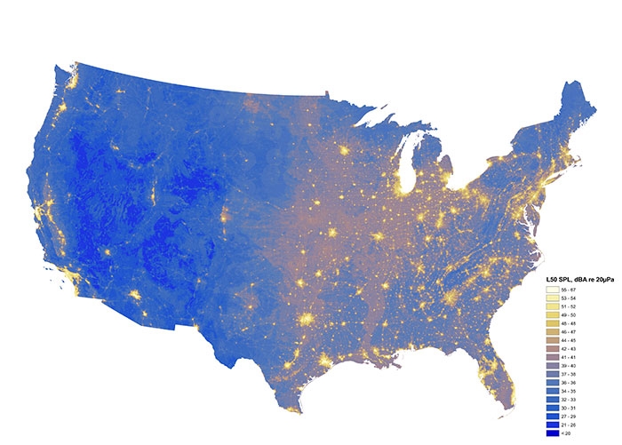 Image source: ational Park Service 9,9822,736Whoa?
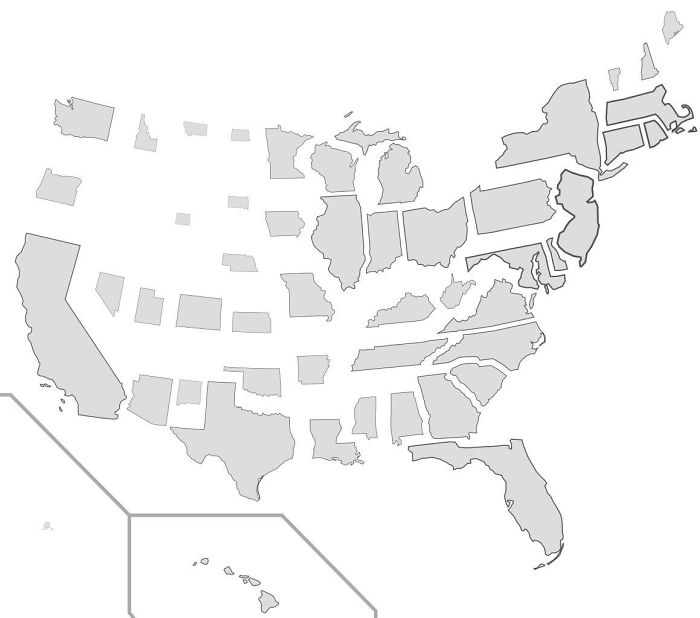 Image source: reddit.com
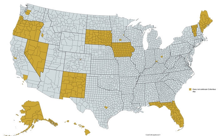 Image source: reddit.com
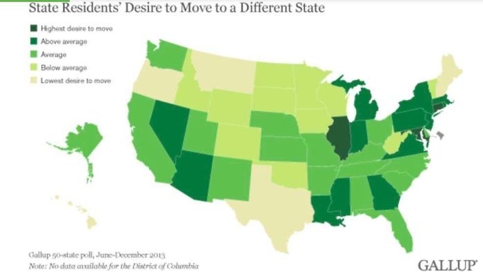 Image source: reddit.com
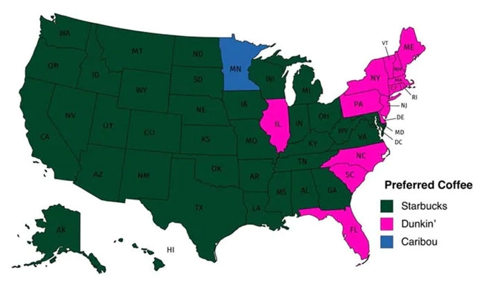 Image source: dannywat3rm3lon
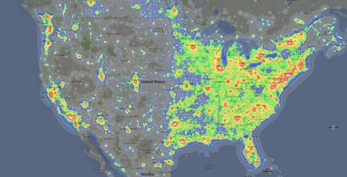 Image source: reddit.com
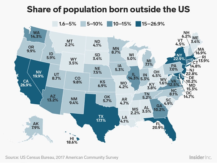 Image source: reddit.com
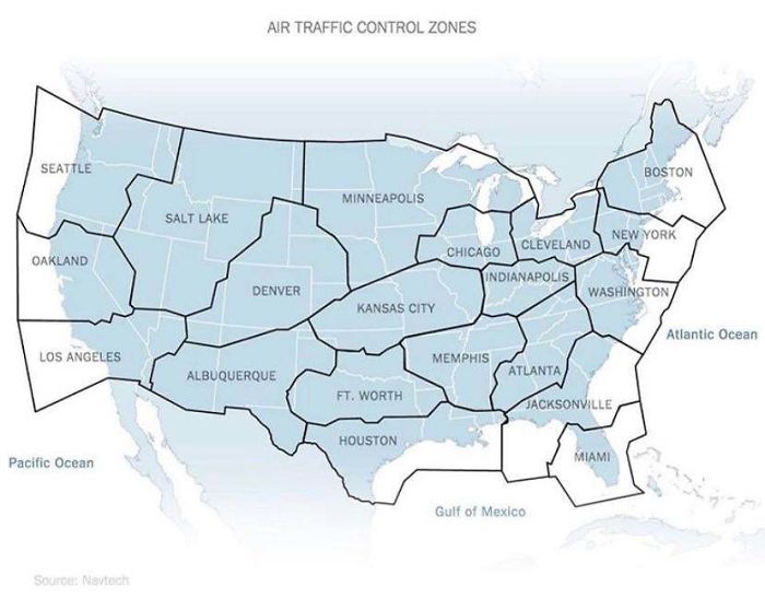 Image source: reddit.com
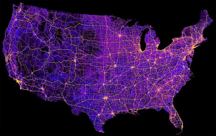 Image source: reddit.com
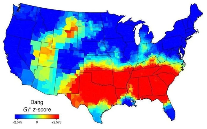 Image source: AJgloe
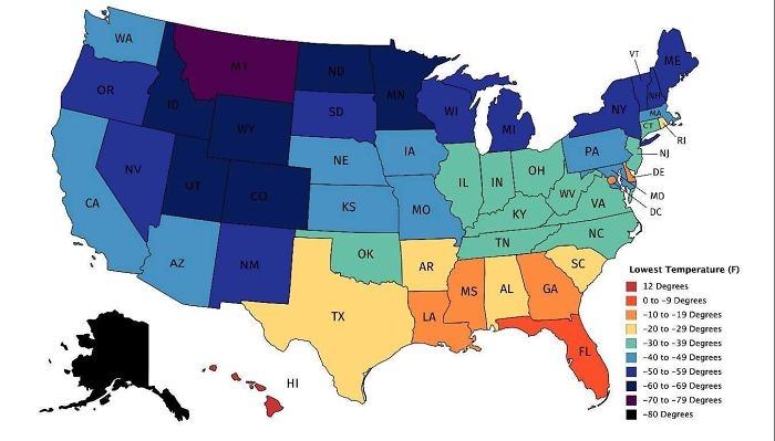 Image source: reddit.com
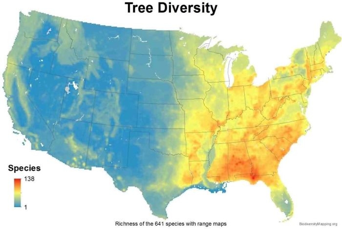 Image source: reddit.com
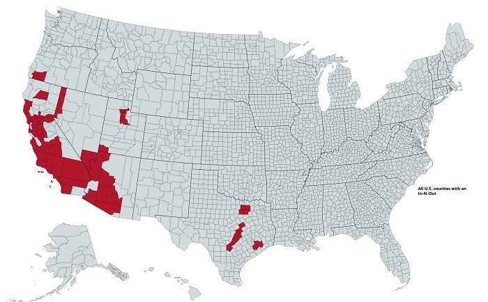 Image source: reddit.com
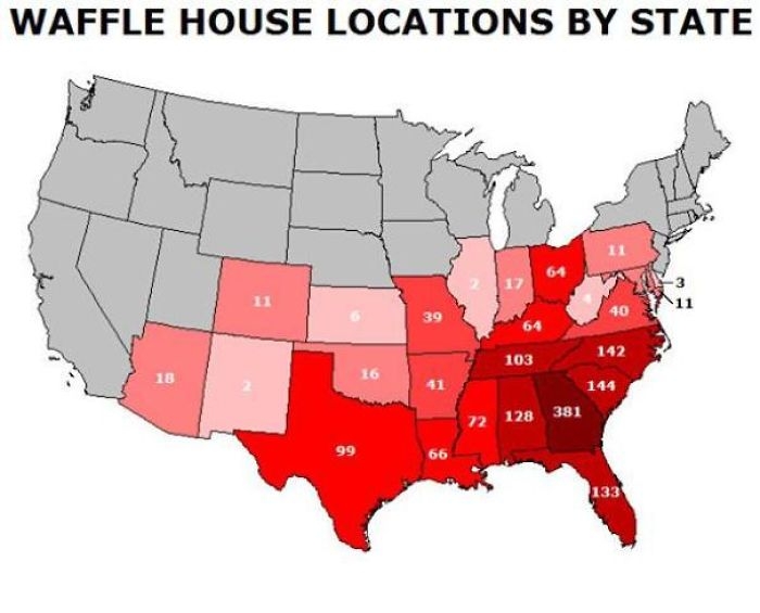 Image source: reddit.com
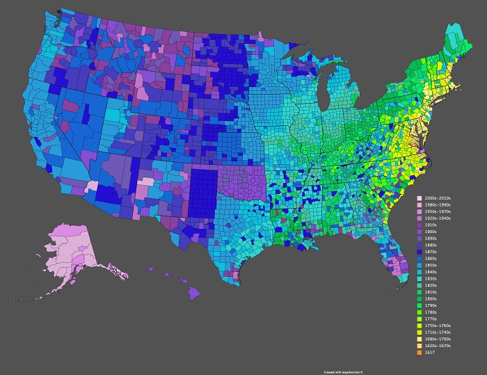 Image source: reddit.com
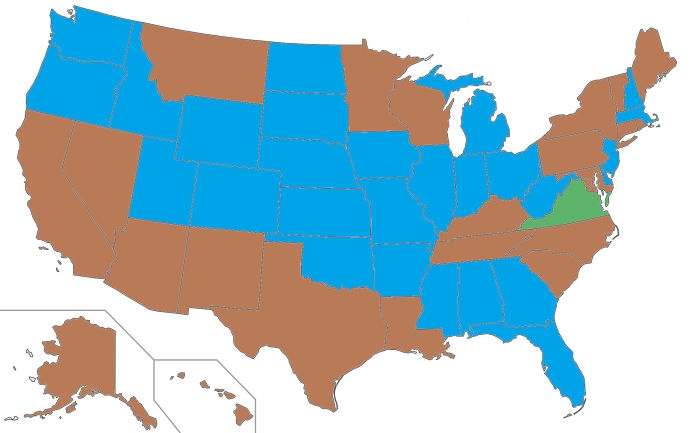 Image source: reddit.com
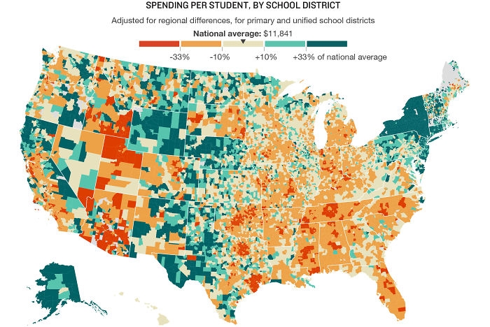 Image source: reddit.com
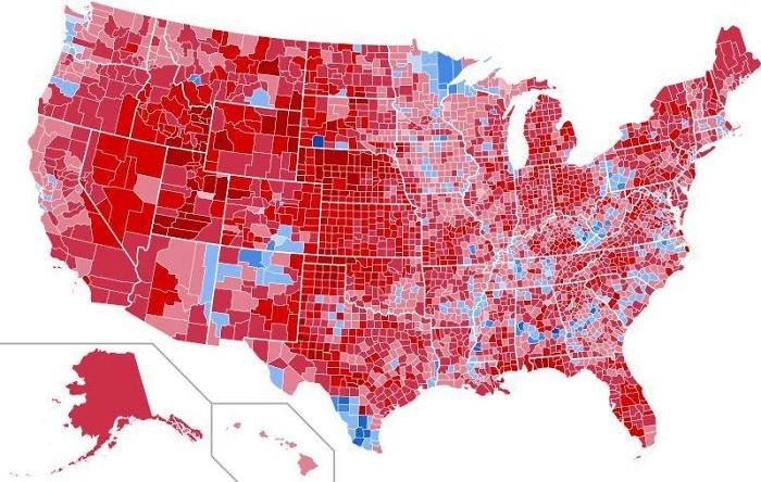 Image source: reddit.com
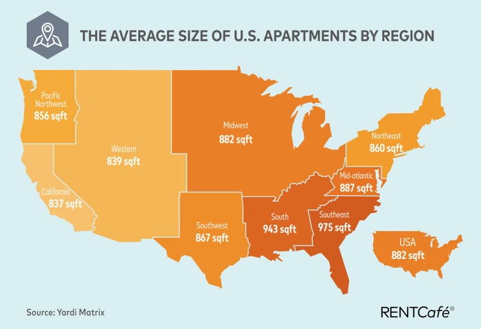 Image source: reddit.com
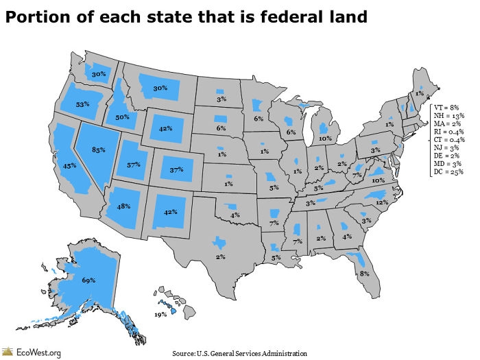 Image source: reddit.com
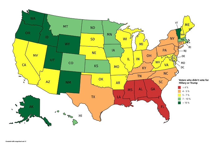 Image source: reddit.com
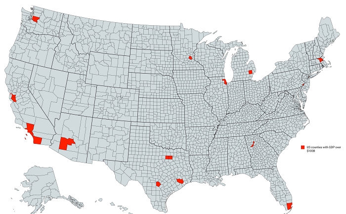 Image source: reddit.com
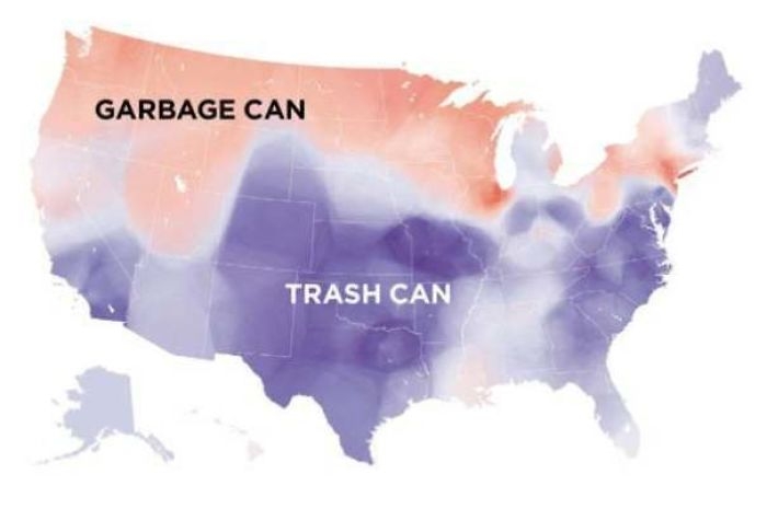 Image source: reddit.com
 Image source: reddit.com
#1 The United States Of America: Alaskan Perspective
Image source: reddit.com
#2 US Watersheds
Image source: reddit.com
#3 How I, A Brit, See The United States (Sorry If It Offends Anyone)
Image source: reddit.com
#4 Most Commonly Spoken Language In The Us After English And Spanish
Image source: reddit.com
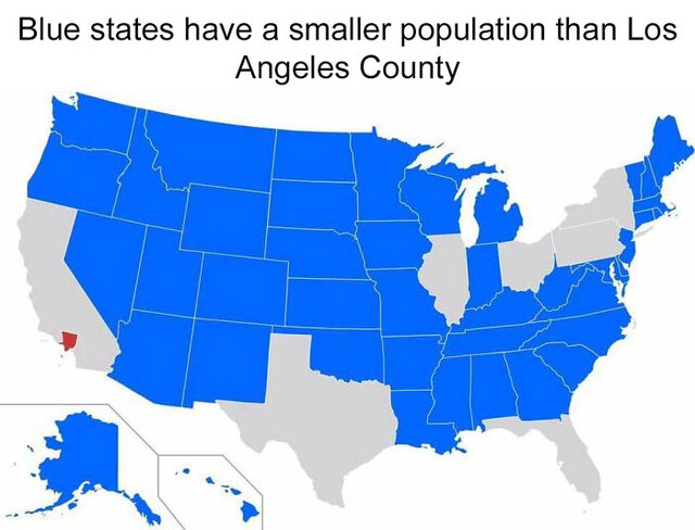
#5 States With A Smaller Population Than Los Angeles County
Image source: reddit.com
#6 Red And Orange Areas Have Equal Populations
Image source: Cogo5646
#7 Every State's Least Favorite State
Image source: reddit.com
#8 How Much Snow Does It Usually Take To Cancel Schools?
Image source: reddit.com
#9 The Most Efficient Route Between Every Springfield In The United States
Image source: reddit.com
#10 United States Population Lines
Image source: reddit.com
#11 Drug Overdose Deaths In The United States Per 100,000 Persons For 1999 And 2014
Image source: reddit.com
#12 Most Common Surname In The United States By State
Image source: reddit.com
#13 Tree Cover Map Of The US
Image source: reddit.com
#14 Its Very Interesting
Image source: reddit.com
#15 More People Live Inside The Red Area Than The Grey Area
Image source: reddit.com
#16 How America Utilizes Its Land
Image source: reddit.com
#17 Out Of Service Railways
Image source: Andrew Grigg/
#18 The Loudest And Quietest Spots In The Continental US
Image source: ational Park Service 9,9822,736Whoa?
#19 US States Scaled Proportionally To Population Density
Image source: reddit.com
#20 Regions Of The U.S. That Don't Officially Celebrate Christopher Columbus Day
Image source: reddit.com
#21 The U.S. Mapped By Residents’ Desire To Move To A Different State
Image source: reddit.com
#22 Popular Coffee Shop Chains By Number Of Locations
Image source: dannywat3rm3lon
#23 Light Pollution In The United States
Image source: reddit.com
#24 Percentage Of People Born Outside The U.S. In Each State
Image source: reddit.com
#25 Air Traffic Control Zones In The USA
Image source: reddit.com
#26 Map Of The United States' 8 Million Miles Of Roads, Streets And Highways
Image source: reddit.com
#27 Use Of The Word "Dang" Across The Continental US
Image source: AJgloe
#28 Map Of Lowest Recorded Temperature In Each Us State (Fahrenheit)
Image source: reddit.com
#29 USA Tree Diversity
Image source: reddit.com
#30 All U.S. Counties With In-N-Out Burger As Of May 2020
Image source: reddit.com
#31 A Tastier Map
Image source: reddit.com
#32 Date Of Creation Of All 3,142 U.S. Counties
Image source: reddit.com
#33 US Governors By Eye Color
Image source: reddit.com
#34 U.S. Education Spending Map
Image source: reddit.com
#35 Results Of The 1984 United States Presidential Election By County. The Most Lopsided Election In History, The Only State Reagan Failed To Win Was His Opponent’s, Minnesota
Image source: reddit.com
#36 Average Size Of US Apartments By Region
Image source: reddit.com
#37 Portion Of Each State That Is Federal Land
Image source: reddit.com
#38 Voters Who Didn't Vote For Hillary Or Trump
Image source: reddit.com
#39 US Counties With Gdp Over $100b
Image source: reddit.com
#40 Garbage Can vs. Trash Can In The United States
Image source: reddit.com
#41 USA Country Map Divided By 1/3rds Of Covid Deaths
Image source: reddit.comDE
Written by
Demilked Editorial
SaaS Review Specialist · Demilked
With 5+ years in the creator, entertainment, and publishing spaces, Demilked shortlists, reviews, and ranks leading tools that actually make your life easier.