
35 Of The Weirdest Things People Spotted On Google Earth
There is an element of fascination for the world that Google Earth fulfils. Travel is no longer an expensive flight away . It is in the palm of your hand, and your only limitation is your imagination. As more and more technological developments give us access to our world, the more we discover. Sitting at our very own comfy desks, we can now idly browse any part of the globe we please.
The Google Earth, Structures and Anomalies Facebook page has some of the most interesting content. The community shares strange Google Earth sightings that made them do a double take while zoomed in scroll below for some screenshots of question about things people saw they left them with more questions that answers.
#1 A Building By My Hometown… Looks Like A Person. A Guy I Think

Image source: Takeo Kun
#2 Go To Your Google Earth And Type Kent St. 44305 In Search And Click Street View You’ll See This Guy, Doing Whatever It Is He’s Doing

Image source: Cinta Kuliner
#3 Guys Guess What I Found This On Google Earth Totally Cool

Image source: Shalu Kumari
#4 Plenty Of Fish In The Sea

Image source: Dane McCormack
#5 In The Waters Of Nagasaki Prefecture, Japan, There Is An Island That Looks Rundown And Messy

Image source: Nicholas Ackerley
Although there are many tall buildings there, there is not a single inhabitant. The island is Hashima Island.
Hashima Island is also often referred to by locals as Gunkajima Island. The island grew in popularity after its story and location were made into a feature film.
Before its popularity as a ‘haunted island’, Hashima Island originally served as an undersea mining operation and a silent witness to Japan’s rapid industrialisation in the 1890s.
Not only were there mines and factories, but there were also residential neighbourhoods.
The availability of jobs led to more and more people settling on the island. By the 1950s, the population had swelled to as many as 5,000.
But as coal power was replaced by petrol, coal prices fell, and many mines, including those on Hashima Island, were permanently closed.
By 1975 the island was completely empty after being abandoned by its inhabitants.
32°37’4″N 129°44’17″E
#6 My Sister Sent This One To Me. This Is One Of My Faves

Image source: James Raid
#7 Submitted Without Comment In Magnolia, TX

Image source: Anonymous participant
#8 The Largest Renewable Energy Park In The World Is Located In Khavda, Gujarat, India, And Is An Amazing Achievement In The Field Of Sustainable Energy
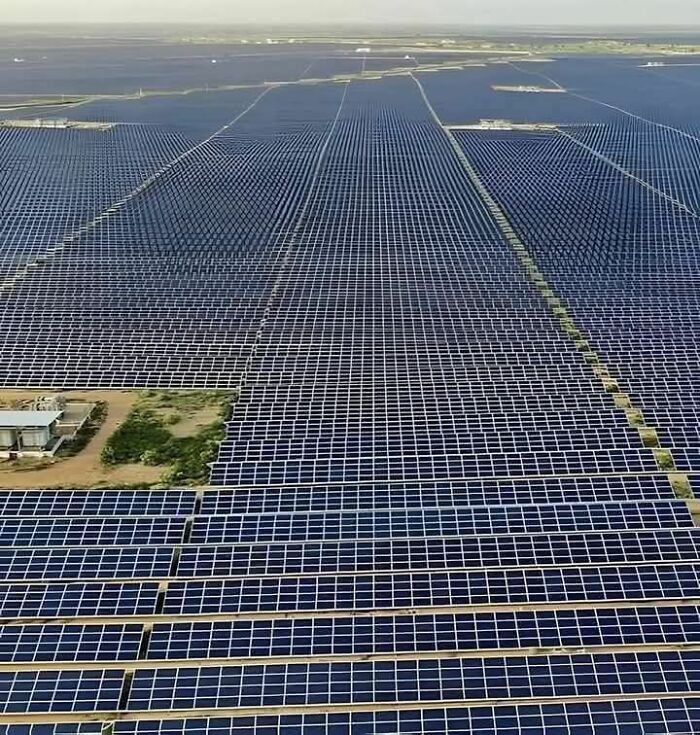
Image source: Babah Hanan Hanaa
#9 Rabbit

Image source: Novita Sarii
#10 The City Of Xico In Mexico, Surrounds A Large Volcanic Crater. Known As ‘Cerro De Xico’, Or “Hill Of Xico”

Image source: Ummu Aqillah Sriwahyuni
The 1-kilometer-wide crater provides fertile soil and naturally protected farmland amid the ever-advancing sprawl of Mexico City.
#11 Spotted Lake, Canada: A Lake That Evaporates In The Summer, Leaving Small Mineral Pools Of Different Colors, Creating A Unique Landscape
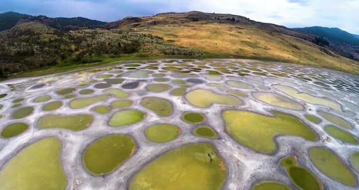
Image source: Jacob Albert
#12 The Baluarte Bridge Is A Suspension Bridge Located In The State Of Durango, Mexico

Image source: Shalu Kumari
It was inaugurated in 2012 and at that time was the tallest suspension bridge in the world, with a height of 403 meters over the Baluarte River. Construction of the bridge began in 2008 and took approximately 4 years to complete. It was designed by the Italian engineer Riccardo Morandi and built by the Mexican company Tradeco. The bridge has a total length of 1,124 meters and connects the states of Durango and Sinaloa, significantly reducing travel time between the two regions.
#13 Castellfollit De La Roca 42°13′17″n 2°33′3″e Is A Municipality In The Comarca Of Garrotxa, In The Province Of Girona, Picturesque Village In Catalonia, Spain

Image source: facebook.com
Perched dramatically atop a 50-meter-high basalt cliff formed by ancient volcanic eruptions.
With origins dating back to the 10th century, this medieval village played a crucial role in regional conflicts due to its defensible position.
The charming streets and traditional stone houses, along with the 13th-century Church of Sant Salvador, reflect its rich history.
Castellfollit de la Roca attracts visitors from around the world with its stunning views and unique geological formation.
#14 Tall Triangle Shaped Tower At Area 51

Image source: Shalu Kumari
#15 Hm

Image source: Pixie Loropetalum
#16 Plane Crash In Northern Russia

Image source: Shalu Kumari
#17 A Japanese Man Rode Over 4,000 Miles To Spell “Marry Me” On Google Earth:

Image source: Momy Amel
Tokyo resident Yasushi “Yassan” Takahashi used GPS technology to propose to his girlfriend.
Inspired by GPS art, where digital drawings are created by traveling preplanned routes with a GPS device, Yassan spent months meticulously planning a journey across Japan using Google Earth. His goal: to spell out the words “Marry Me” across the country.
Quitting his job and setting off in June, Yassan traveled 4,451 miles from Hokkaido to Kagoshima over six months, documenting his path.
When uploaded to Google Earth, the massive “Marry Me” message was revealed, earning him a Guinness World Record for the largest GPS drawing in history.
Today, GPS art has become a global phenomenon, combining creativity, travel, and technology to transform landscapes into canvases for drawings as varied as animals, fictional characters, and intricate designs.
#18 Google Earth Has Begun Updating Images Of Gaza Before And After

Image source: Jon Renan
#19 Baljenac Island, A Unique Island In Croatian Waters, Stretches Around The Adriatic Sea, A Sea That Separates Italy And The Balkans

Image source: facebook.com
Uniquely, this small 14-hectare island, when viewed from above, resembles a fingerprint with its distinctive strokes and curves.
The fingerprint-like lines embedded on this uninhabited island are actually artefacts of stone walls surrounded by trees.
The stone walls, which stretch for 23 kilometres, mark the boundaries of each plantation.
#20 Unknown Two Shipwrecks In Venezuela

Image source: Leo De Sousa
#21 Found On Google Earth Page In Russia. Looks Like Giants Walking Up The Hill

Image source: Emmie Lee
#22 Unsettling Message Spotted On Google Earth Near Cesar Chavez Ave, La: “Help,” “Trafico,” “Lapd,” And “Federal” Written In Debris Coordinates: 34°03’17.8”n, 118°13’32.2”w

Image source: Roddy
#23 On Google Earth In Pyongyang, North Korea

Image source: 𝙆𝙤𝙣𝙖 & 𝙍𝙤𝙣𝙮
#24 I Did Not Know An Italian Island Has Real Hobbits Who Live In The Ground In Real Hobbit Holes

Image source: Anonymous participant
#25 Found This Weird Island, Anyone Know Why The Trees Would Be Laid Out In Such Straight Lines??

Image source: Jacob Albert
Obviously not impossible to do, but I don’t know why anyone would put so much effort into planting a grid of trees on a random island
#26 Sketchiest Ice Cream Truck I’ve Ever Seen!

Image source: Edith Elder
#27 What In The Loch Ness Monster Sh*t Is Going On In Utah

Image source: Greg Hill
#28 Everyone Wants To Fit In ! Antarctica

Image source: Anonymous participant
#29 Tupolev Tu-144 “Concordski” Russian Concorde Why Would Someone Park A Tu-144 Supersonic Passenger Jet In The Middle Of Town? And Better Yet, Why Would They Abandon It?

Image source: Jacob Albert
#30 Found Some Buildings In China Spelling Out The Word Of “Antibody”

Image source: facebook.com
Here is the coordinates, you can check on every maps like google, bing, baidu etc.
31°39’48″N,117°54’25″E
Or this coordinate for apple maps user, you can copy and paste this:
31,66330°N, 117,90704°E
*Ps these images are not photoshopped or AI Generating, they are for real. You can check it by yourself
#31 Found Where I Should Have Been Born

Image source: Swarup Biswas
#32 Crazy How The Aral Sea Got Drained So Much.wow

Image source: Angelica Danhagen
#33 Omg

Image source: Ella Fazila
#34 Stunning Formation In The South Of Algeria. I Wonder What It Is?

Image source: Curt Junior
#35 Meteor Crater And Barringer Space Museum Near Winslow, Arizona

Image source: Amberia


Got wisdom to pour?