
30 Maps That Show The World From A Completely Different Angle
Maps have long been more than just navigational tools; they are windows into the world’s diverse cultures, histories, and geographies. The Instagram page Amazing Maps takes this concept to the next level by curating fascinating, insightful, and sometimes downright surprising maps from around the globe.
If you love exploring the world from the comfort of your screen, Amazing Maps is a must-follow. It’s a space where geography meets creativity, and where every post leaves you with a new nugget of knowledge. Whether you’re a map geek or just curious about global trivia, we’ve collected some of the best posts from this page to spark your interest.
#1 How A Coastline 100 Million Years Ago Influences Modern Election Results In Alabama

Image source: amazingmap
#2 Virgin Forest Cover 1620 vs. Today

Image source: amazingmap
#3 Kiribati Is The Only Country In The World That Is In All Four Hemispheres

Image source: amazingmap
#4 Regional Giraffe Patterns

Image source: amazingmap
#5 Passenger Trains In The United States vs. Europe

Image source: amazingmap
#6 Each Section Has 10% Of The World’s Population

Image source: amazingmap
#7 In 1992, Around 29,000 Rubber Ducks Fell Off A Cargo Ship In The Pacific Ocean. This Is Where They Made Landfall
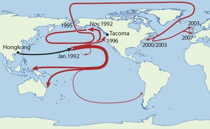
Image source: amazingmap
#8 Cycle Paths Of Europe

Image source: amazingmap
#9 A Map Comparing Actual Distances To Their Representation On The Mercator Projection

Image source: amazingmap
#10 Railways In China, 2008 vs. 2020

Image source: amazingmap
#11 Obesity In North America (2021)

Image source: amazingmap
#12 The First World Map By Anaximander Of Miletus (610bc-546bc), Greek Philosopher

Image source: amazingmap
#13 Homicide Rates In Different Regions Of The World

Image source: amazingmap
#14 The Spilhaus Projection. In 1942, Athelstan Spilhaus Produced A World Map With A Unique Perspective, Presenting The World’s Oceans As One Body Of Water

Image source: amazingmap
#15 Historical And Current Grizzly Bear Range In North America

Image source: amazingmap
#16 Countries Where Cheek Kissing Is A Common Greeting

Image source: amazingmap
#17 A Map Of Geography Terms. Any You Didn’t Know?

Image source: amazingmap
#18 Xinjiang, China. The Farthest Place On Earth From Any Ocean

Image source: amazingmap
#19 Map Of The 1910 Tour De France Route

Image source: amazingmap
#20 The Red And Orange Areas Have Equal Population

Image source: amazingmap
#21 Comparing The Urban Areas Of European Capitals

Image source: amazingmap
#22 A Portuguese Propaganda Poster Showing The Size Of Portuguese Colonial Possessions Compared To Europe

Image source: amazingmap
#23 Dividing British Columbia Into Three Regions With Equal Population

Image source: amazingmap
#24 North America 92 Million Years Ago

Image source: amazingmap
#25 Map Of Languages Spoken In China

Image source: amazingmap
#26 Highway 1 In Australia. The Longest National Highway In The World At Around 14,500km

Image source: amazingmap
#27 Location Of Every City Founded By The Roman Empire, Outside Of Italy
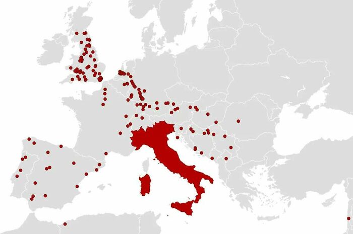
Image source: amazingmap
#28 Melbourne Is Closer To Antarctica Than It Is To Darwin

Image source: amazingmap
#29 The Roundest Countries

Image source: amazingmap
#30 A Map Of The World Constructed From Time Zones

Image source: amazingmap


Got wisdom to pour?