
20 Unique Maps That Show Things From A Different Perspective Shared To This Online Group (New Pics)
Even if geography isn’t really your thing, you have to admire the art of map making since there’s so much information you can fit in a single image. And if you though that they can only be used for marking streets or country borders, you couldn’t be more wrong.
Today we have prepared you a collection of the most interesting and unusual maps shared to the r/MapPo*n subreddit, and they will make you see geography from a whole different perspective. From maps showing traditional rug patterns to ones showing empires at their peak, check out a collection of the most interesting maps that you won’t find in your regular textbooks in the gallery below! And if you want more, make sure to read our previous post here!
#1 Map Of Regional Rug Patterns Of Iran

Image source: knownothingwiseguy
#2 Oklahoma Man Hole Covers Have A City Map On, With A Blue Dot To Show Where You Are

Image source: CatherineCortez
#3 World Map Mural

Image source: eveildancer
#4 Animals Of The World Map

Image source: ShapeShiftingCats
#5 A Map Of All Of The World’s Roads

Image source: RossBoss31
#6 My Great Grandpa Drew This Map Of Africa In The 1910’s

Image source: zherper
#7 Europe In The Style Of Super Mario

Image source: vladgrinch
#8 Abstract World Map

Image source: CHWDP_2137
#9 Someone Joked That Instead Of Google Earth I Should Make Doodle Earth. I Liked The Idea So I Gave It A Shot

Image source: tfoust10
#10 Most Popular Lastnames In Europe

Image source: vitor350z
#11 Since You All Liked My Great Grandpa’s Drawing Of Africa At Age 12, Here’s One He Did Of Asia (Ca. 1910’s)

Image source: zherper
#12 United States Elevation Map

Image source: blntdfam
#13 The Roman Empire vs. The Mongol Empire At Their Peaks

Image source: vladgrinch
#14 An Artists’ Impression Of The Roman Port City Of Londinium, Established Between 47-50 Ad

Image source: last_goodbye1
#15 Some Alternate Maps Of Down Under
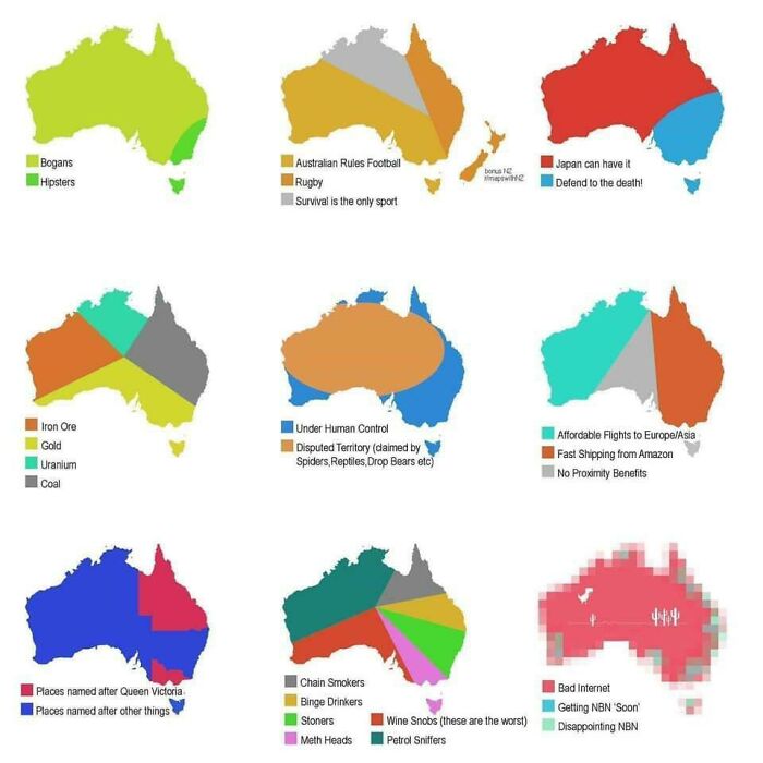
Image source: UggBootPimpJuice
#16 Countries That Recognises The Uyghur Genocide As Of February 26, 2021

Image source: Blulien
#17 The Iberian Peninsula At Night By Nasa

Image source: Homesanto
#18 World Map Resized According To Population

Image source: fasterthanksi
#19 Place Names That Contain The Word ‘Peak’, ‘Mountain’, ‘Ridge’, ‘Plain’ And ‘Field’ In The United States

Image source: AJgloe
#20 Map Of Most Photographed Places In The World

Image source: the-70s-kid


Got wisdom to pour?
Awesome arts on maps, it can make boring tasks intresting.
17. The Korean Peninsula at night is more fascinating! Check it out.