
20 Of The Most Interesting Maps Shared By This Instagram Page To Teach You Something New
Enough with the boring textbooks and hard-to-read excel spreadsheets. Infographics are a new way to share information. For those unaware, an infographic is a graphic visual that features various imagery, data visualizations (e.g., pie charts), and short text to help grasp the information more easily. To put it more simply, it’s a story told through visuals.
Perhaps other than being visually appealing, infographics convey valuable information. This Dutch cultural geography & tourism student turned his passion for maps, atlases, and history into a social media project named ‘A Map A Day.’ The creator shares infographic maps and other geographical oddities to provide the people with exciting yet educational facts.
After you’re done with the post, check out our previous articles featuring some of the most interesting maps here and here!
#1 Everyone In The World Could Fit Into A 50km Diameter Circle

Image source: amapaday
#2 ‘Nobody Lives Here’, 1x1km Areas In The United Kingdom Where The Reported Population Equals Zero

Image source: amapaday
#3 Sharks vs. Humans (2014)

Image source: amapaday
#4 Global Distribution Of Penguins

Image source: amapaday
#5 Land Use Comparison Of A Typical European City And A North American City
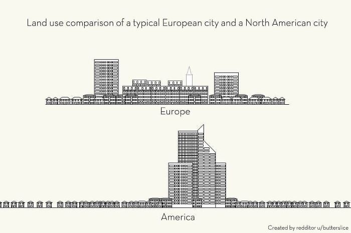
Image source: amapaday
#6 The United Pixels Of America

Image source: amapaday
#7 The North American Cryptid Map

Image source: amapaday
#8 Cause Of Death – Reality vs. Google vs. Media

Image source: amapaday
#9 How To Read Tree Rings. The Color And Width Of Tree Rings Can Provide Snapshots Of Past Climate Conditions

Image source: amapaday
#10 Eight Minimalist Maps
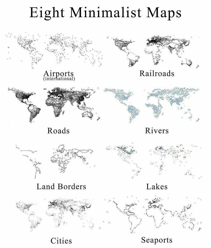
Image source: amapaday
#11 Most-Used Word In Each State

Image source: amapaday
#12 Visual Guide To Geographic Terms

Image source: amapaday
#13 States With A Smaller Population Than Los Angeles County

Image source: amapaday
#14 When Two City Planners Hate Each Other (Missoula, Montana)

Image source: amapaday
#15 The Many Flags Inside Norway’s Flag

Image source: amapaday
#16 Closeness Over Time

Image source: amapaday
#17 The Timeline Of A Tree

Image source: amapaday
#18 Using The Statue Of Liberty To ‘Map’ How Copper Goes Through The Oxidation Process

Image source: amapaday
#19 How The Solar System Travels Through The Galaxy

Image source: amapaday
#20 A Bar In Dc Made A Us Map From One Summer’s Confiscated Fake Id’s

Image source: amapaday


Got wisdom to pour?